 Cdr. Jim Waldron was one of the first
Deep Freeze pilots and recounts some of his experience in picture form here. He wrote a book on
his
times and trials of the early days of U.S. Antarctic operations.
Cdr. Jim Waldron was one of the first
Deep Freeze pilots and recounts some of his experience in picture form here. He wrote a book on
his
times and trials of the early days of U.S. Antarctic operations.
He has prepared a CD disk containing his thirty chapter book entitled,
"The
Flight of the Puckered Penguins",
plus over 150 color photographs. The book
and the photos detail Cdr. Waldron's flying experiences during his sixteen
months on the Antarctic Continent. The book is in HTML format and the
photographs are in JPEG format (130 dpi).
Anyone interested in ordering a copy of the CD should send a check or money
order for $20.00, plus their mailing address, to: Jim Waldron, 12617 Meghans Bay
Court, Richmond, VA 23231-3344. Overseas shipments should add postage for 4
ounces of shipping weight.
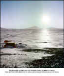
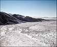
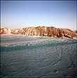
 Here
is the roadway leading from Little America FIVE to the edge of the Ross Ice
Shelf, where the cargo ships were offloaded of their cargo. Once offloaded the
cargo was placed in rows for later transfer to base camp. After the ships had
departed snows tended to cover the cargo so there was a 24 hour per day movement
of tractors to recover the cargo before it was lost below the snow. The
helicopter was also used to move frozen food to the galley storage area. With
winter fast approaching the temperatures were extremely low and the work was
quite physically difficult as a result.
Here
is the roadway leading from Little America FIVE to the edge of the Ross Ice
Shelf, where the cargo ships were offloaded of their cargo. Once offloaded the
cargo was placed in rows for later transfer to base camp. After the ships had
departed snows tended to cover the cargo so there was a 24 hour per day movement
of tractors to recover the cargo before it was lost below the snow. The
helicopter was also used to move frozen food to the galley storage area. With
winter fast approaching the temperatures were extremely low and the work was
quite physically difficult as a result.
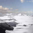 When
Captain Scott and his men walked to the South Pole he could only see to
the hills just in front of him. Scenes of distant grandeur, such as this
mountain view, can only be appreciated from high altitude.
When
Captain Scott and his men walked to the South Pole he could only see to
the hills just in front of him. Scenes of distant grandeur, such as this
mountain view, can only be appreciated from high altitude.
This picture was taken en-route to Pole Station Christmas Eve of 1956.
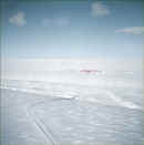 This
rather insignificant photograph tells a few stories that are not quite so
apparent at first glance. It was taken from the base helicopter over Kiel Field,
looking directly northward. Kiel Field was where our four R4Ds, six Otters and
one helicopter were flown from. In the foreground the roadway points to Little
America FIVE shown in the mid ground. Along the way the road dips downward into
a small valley. This point is where the ice fractured a few years later allowing
Little America FIVE to break away from the Ross Ice Shelf, becoming another
iceberg. Not seen in the photograph are the many flags spaced along the edge of
the road. These once-red flags were mounted on bamboo poles, however, they
quickly faded to light pink once exposed to the 24 hours of sunlight of the
Antarctic summer. The horizon you see in the picture is not the real horizon but
the edge of the Ross Ice Shelf. The actual horizon is a bit lower and masked by
the ice edge, which is about four miles from Kiel Field.
This
rather insignificant photograph tells a few stories that are not quite so
apparent at first glance. It was taken from the base helicopter over Kiel Field,
looking directly northward. Kiel Field was where our four R4Ds, six Otters and
one helicopter were flown from. In the foreground the roadway points to Little
America FIVE shown in the mid ground. Along the way the road dips downward into
a small valley. This point is where the ice fractured a few years later allowing
Little America FIVE to break away from the Ross Ice Shelf, becoming another
iceberg. Not seen in the photograph are the many flags spaced along the edge of
the road. These once-red flags were mounted on bamboo poles, however, they
quickly faded to light pink once exposed to the 24 hours of sunlight of the
Antarctic summer. The horizon you see in the picture is not the real horizon but
the edge of the Ross Ice Shelf. The actual horizon is a bit lower and masked by
the ice edge, which is about four miles from Kiel Field.
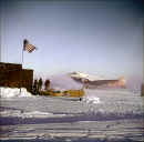 This
photo was taken early in the summer of 1956 which is evident from the low sun
angle. The flag gives it a patriotic feeling.
This
photo was taken early in the summer of 1956 which is evident from the low sun
angle. The flag gives it a patriotic feeling.
This is a rare view since it includes an early morning low sun angle and
a
full moon in the background. It is August or September 1957, the winter night
has just ended and temperatures have risen to about -35 degrees F. We have
just started digging this R4D from the snow that has almost covered it.
 About
a mile from NAF McMurdo is a rough area where the sea ice meets the Ross Ice
Shelf. Due to tidal movements and the enormous ice pressures that build up the
sea ice is pushed up into slabs and various folded shapes. Here, in 1956, I
photographed some folded ice shapes with the smoking Mount Erebus in the
background. Mount Erebus is the only active volcano on the Antarctic Continent.
NAF McMurdo is built along the base of Mount Erebus. In the distance one can see
two seals on the ice. The seals come up through weak spots in the sea ice and
deliver their pup seals. After delivering the pup seals the mother seals teach
their pups how to keep open their breathing holes in the ice. She also teaches
them how to feed themselves from the ocean below.
About
a mile from NAF McMurdo is a rough area where the sea ice meets the Ross Ice
Shelf. Due to tidal movements and the enormous ice pressures that build up the
sea ice is pushed up into slabs and various folded shapes. Here, in 1956, I
photographed some folded ice shapes with the smoking Mount Erebus in the
background. Mount Erebus is the only active volcano on the Antarctic Continent.
NAF McMurdo is built along the base of Mount Erebus. In the distance one can see
two seals on the ice. The seals come up through weak spots in the sea ice and
deliver their pup seals. After delivering the pup seals the mother seals teach
their pups how to keep open their breathing holes in the ice. She also teaches
them how to feed themselves from the ocean below.
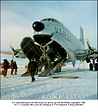
 As
the long winter of 1957 came to an end, we started digging out our aircraft for
the summer months ahead. This is the first R4D to be dug out of the snow and
Herman Nelson heaters are hard at work defrosting the aircraft. The rudders and
ailerons were removed at the start of the winter and they have not been
reinstalled at the time the picture was taken. The temperature at the time this
photo was taken was about -35 degrees Fahrenheit. Men working on the aircraft
were limited to just a few minutes before they had to return to the Maintenance
Building to thaw out.
As
the long winter of 1957 came to an end, we started digging out our aircraft for
the summer months ahead. This is the first R4D to be dug out of the snow and
Herman Nelson heaters are hard at work defrosting the aircraft. The rudders and
ailerons were removed at the start of the winter and they have not been
reinstalled at the time the picture was taken. The temperature at the time this
photo was taken was about -35 degrees Fahrenheit. Men working on the aircraft
were limited to just a few minutes before they had to return to the Maintenance
Building to thaw out.
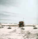 This was the lead vehicle in the scientific traverse party which mapped out
the Ross Ice Shelf. As the vehicle progressed slowly over the ice shelf it
generated sub-sonic sound waves from the three saucer shaped objects just
forward of the vehicle itself. Inside the cab of the vehicle was electronic
readouts of the sound waves that bounced off anomalies in the ice. In effect
it told the driver of the vehicle when he was about to drive over a hidden
crevasse so he could alter his course and avoid falling into one of these
large hidden breaks in the ice.
This was the lead vehicle in the scientific traverse party which mapped out
the Ross Ice Shelf. As the vehicle progressed slowly over the ice shelf it
generated sub-sonic sound waves from the three saucer shaped objects just
forward of the vehicle itself. Inside the cab of the vehicle was electronic
readouts of the sound waves that bounced off anomalies in the ice. In effect
it told the driver of the vehicle when he was about to drive over a hidden
crevasse so he could alter his course and avoid falling into one of these
large hidden breaks in the ice.
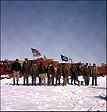
There
were two R4D aircraft commanders who wintered over at Little America V in 1957.
They were Lcdr. Bob Anderson (left in photograph) and Lcdr. Harvey Speed (right
in photograph). Both made many long and arduous flights in support of Operation
Deep Freeze.
Harvey Speed was an exceptional and fearless pilot and was known by everyone who
spent any time on the Continent in 1956 and 1957. He once made a late
summer flight to the South Pole when temperatures were extremely cold and after
squadron aircraft and 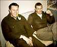 Air Force C-124 aircraft had left the Ice for their return
to the United States. On the return flight from Pole Station, while still over
the Antarctic Ice Cap he lost oil pressure on one engine due to oil lines
freezing and was forced to make a forced landing. He spent several hours on the
surface of the ice while his maintenance crew repaired the oil lines. His
exceptional airmanship resulted in a successful flight
when the odds of completing the flight were stacked against him.
Air Force C-124 aircraft had left the Ice for their return
to the United States. On the return flight from Pole Station, while still over
the Antarctic Ice Cap he lost oil pressure on one engine due to oil lines
freezing and was forced to make a forced landing. He spent several hours on the
surface of the ice while his maintenance crew repaired the oil lines. His
exceptional airmanship resulted in a successful flight
when the odds of completing the flight were stacked against him.
Harvey Speed died of Lou Gehrig's Disease in Pensacola, Florida long after his
Antarctic flying days.
=
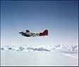
 Here
is a picture of Que Sera Sera taken at the foot of the Beardmore Glacier in
September 1957. The great Harvey Speed is at the controls.
Here
is a picture of Que Sera Sera taken at the foot of the Beardmore Glacier in
September 1957. The great Harvey Speed is at the controls.
 Broken Ice
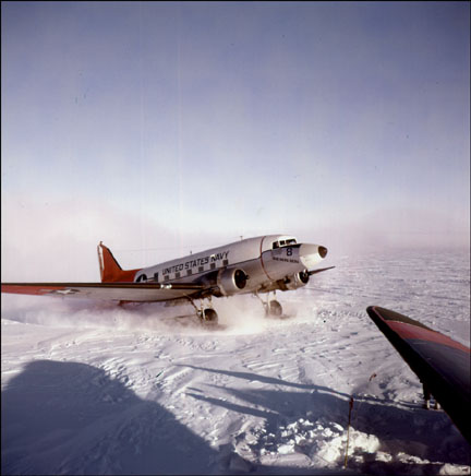
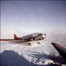
 R4D
' Charlene ' Taxiing
R4D
' Charlene ' Taxiing
This is an aerial photograph of Little America FIVE, taken in about
February 1957, from the station helicopter. The buildings are as of then
uncovered by snow. After the winter months still ahead the buildings were mostly
covered by snow. All buildings were connected by a common tunnel so that one did
not have to go outside into the super cold temperatures to traverse between
buildings.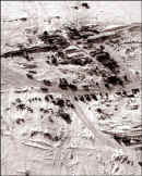
A few years after this picture was taken the ice which held Little
America FIVE broke off from the continent and floated northward, only to
melt and sink below the sea. The camp had been abandoned before this happened and vital equipment and personnel were
evacuated to other locations.
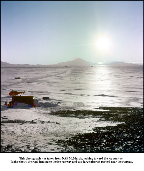
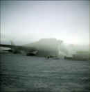
 This
photograph was taken from "Top of the Hill" at NAF McMurdo. Ahead is
the road leading to the ice runway where two large aircraft are parked.
This
photograph was taken from "Top of the Hill" at NAF McMurdo. Ahead is
the road leading to the ice runway where two large aircraft are parked.
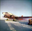
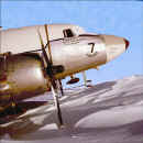 This
photo is of No. 7, the Takahe, after it was partially dug out from the winter
snows at Little America V, in 1957.
This
photo is of No. 7, the Takahe, after it was partially dug out from the winter
snows at Little America V, in 1957.
 C-124 Offloading
 Here are some reddish
colored mountains just south of Minna Bluff.
Here are some reddish
colored mountains just south of Minna Bluff.
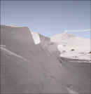
 This photograph was taken
just south of Minna Bluff where the northward moving Ross Ice Shelf is caught in
a cul-de-sac. The result is a area of disturbed ice that lasts for many square
miles.
This photograph was taken
just south of Minna Bluff where the northward moving Ross Ice Shelf is caught in
a cul-de-sac. The result is a area of disturbed ice that lasts for many square
miles.
 A snapshot of the
members of the first Tractor Train Party just prior to
departing Little America FIVE for Marie Byrd Station, 1956.
A snapshot of the
members of the first Tractor Train Party just prior to
departing Little America FIVE for Marie Byrd Station, 1956.
This is a photo of Beardmore Station, at the foot of the Liv Glacier, during 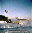 the
early summer months of 1956. Our flight crew sat in our R4D at this location for
many hours as a standby rescue aircraft should Cdr. Gus Shinn's
the
early summer months of 1956. Our flight crew sat in our R4D at this location for
many hours as a standby rescue aircraft should Cdr. Gus Shinn's
aircraft have gotten stuck on the South Pole or if it were forced down on the
polar ice cap.
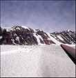
I took this horizontal view from inside a crevasse that was about 12 feet
wide. In the distance the bridge over the crevasse has collapsed and snow has
partially filled the gap. The side walls of this crevasse appears rough, however, this roughness is only a
light frost that sticks to the walls and can be easily removed by passing your
glove over it. The walls are, in fact, smooth clear blue ice. Inside the
crevasse, only blue light is evident. The other colors of the color spectrum are
filtered out.
The side walls of this crevasse appears rough, however, this roughness is only a
light frost that sticks to the walls and can be easily removed by passing your
glove over it. The walls are, in fact, smooth clear blue ice. Inside the
crevasse, only blue light is evident. The other colors of the color spectrum are
filtered out.
About a mile south of NAF McMurdo the sea ice meets the continental ice. Here
tremendous pressures are experienced as the two ice masses move against each
other. 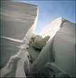 Slow,
relentless pressures sometime fold the sea ice, rather than cracking or
crumbling it. In this scene one can see how the ice is bent into
a loop shape. In other places along this area of disturbed ice one can see slabs
of sea ice that have been pushed into a near vertical position.
Slow,
relentless pressures sometime fold the sea ice, rather than cracking or
crumbling it. In this scene one can see how the ice is bent into
a loop shape. In other places along this area of disturbed ice one can see slabs
of sea ice that have been pushed into a near vertical position.
Whenever we flew south from NAF McMurdo we flew over a heavily crevassed
 area. This area was about 50 miles south of NAF McMurdo. This picture was
taken in September 1957 when the sun was still at a low angle and the
sunlight highlighted the edges of the crevasses.
area. This area was about 50 miles south of NAF McMurdo. This picture was
taken in September 1957 when the sun was still at a low angle and the
sunlight highlighted the edges of the crevasses.
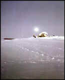
This is not a particularly dramatic picture, nor should it be memorable to
anyone who hasn't been there, however it was very meaningful to those of us who
were to winter over on the Continent. 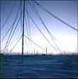 Here
is a view of the Little America FIVE antenna farm just after the sun has set for
four months. It was the final indication that a long winter night was to follow
and all 400 inhabitants at the base were totally isolated from the rest of the
world. Our only contact with the outside world would flow towards us through
those same antenna cables as are seen in the photograph.
Here
is a view of the Little America FIVE antenna farm just after the sun has set for
four months. It was the final indication that a long winter night was to follow
and all 400 inhabitants at the base were totally isolated from the rest of the
world. Our only contact with the outside world would flow towards us through
those same antenna cables as are seen in the photograph.
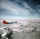
September 1957. Photograph taken of Shackleton Coast, with Byrd Glacier on
 right
side. The R4D aircraft is enroute to the Beardmore Glacier in order to set up a
radio and weather relay station for summer operations.
right
side. The R4D aircraft is enroute to the Beardmore Glacier in order to set up a
radio and weather relay station for summer operations.
 Cdr. Jim Waldron was one of the first
Deep Freeze pilots and recounts some of his experience in picture form here. He wrote a book on
his
times and trials of the early days of U.S. Antarctic operations.
Cdr. Jim Waldron was one of the first
Deep Freeze pilots and recounts some of his experience in picture form here. He wrote a book on
his
times and trials of the early days of U.S. Antarctic operations.  Here
is the roadway leading from Little America FIVE to the edge of the Ross Ice
Shelf, where the cargo ships were offloaded of their cargo. Once offloaded the
cargo was placed in rows for later transfer to base camp. After the ships had
departed snows tended to cover the cargo so there was a 24 hour per day movement
of tractors to recover the cargo before it was lost below the snow. The
helicopter was also used to move frozen food to the galley storage area. With
winter fast approaching the temperatures were extremely low and the work was
quite physically difficult as a result.
Here
is the roadway leading from Little America FIVE to the edge of the Ross Ice
Shelf, where the cargo ships were offloaded of their cargo. Once offloaded the
cargo was placed in rows for later transfer to base camp. After the ships had
departed snows tended to cover the cargo so there was a 24 hour per day movement
of tractors to recover the cargo before it was lost below the snow. The
helicopter was also used to move frozen food to the galley storage area. With
winter fast approaching the temperatures were extremely low and the work was
quite physically difficult as a result.