![]()
![]()
Selectman Authorize Private
Ways
Board of Survey - Mass Laws
Typical Road Section
Chapter 90 Fund
Accepted Ways
Un-Accepted Ways
Private Common Driveways
Private Ways
Paper, Discontinued, Name Change Ways
Sidewalks
![]()
This shows a typical street lay out of Engineering
construction of building a street and every thing that is inside a street lay out as width
of street, sidewalks, utility poles, under ground utilities, curbing, laying of water
lines, gas lines, storm drainage lines, sewer lines, also what materials to be use to
constructing a street.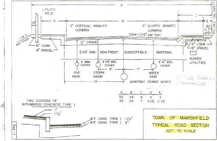
Anything to do with this layout, Chapter 90 / 115 Funds will pay for and (there will be no damages or land takings and etc. would have to be paid by the Town) for lets say building a sidewalk.
A good Town by-Law and enforceable by-law should be written on encroachments into the street layouts of this Town. There are rocks, fences, bushes, trees that are causing safety hazards in this town. The only thing from your property line to the black top should be grass and the homeowner should maintain that by cutting the grass even though they do not own it and that would keep our town looking nice.
I personally have not planted anything
other than on my property but I have always cut my grass right out to the black top so my
own property looks nice in my area.
Selectmen Built Private Ways of the Town
Mass General Laws- Acts of 1786,Chapter 67
By Bob Cheeseman
[January Session, chapter 15.] AN ACT DIRECTING THE METHOD FOR LAYING OUT HIGHWAYS.
[Selectmen empowered to lay out particular and private ways]
Be it enacted by the Senate and House of Representatives, in General Court assembled, and by the authority of the same, that the Selectmen of the several Towns in this Government, are herby authorized and empowered, either personally, or by such other Person or Persons, as they shall appoint, to lay out within their respective Towns, particular and private ways, for the use of such Town only; or for the use of one or more individual thereof, or proprietors therein; and if any particular Person or Persons, who are Owners of land through which such private Roads shall be laid out, be injured, he or they shall receive such recompence, as the party interested and the Selectmen shall agree upon, to be paid by the Town, or the individual Person or Persons, for whose use the road is laid out, or as shall be ordered by the Justices in their General Sessions of the Peace, upon an enquiry into the same by a Jury to be summoned for that purpose, or by a special Committee, if the Parties agree thereunto.
Provided always, that no private way laid out by the Selectmen, or their order, as aforesaid, shall be established as such, until the same has been reported to the Town, at some public meeting of the Inhabitants thereof, regularly notified and warned, and by them approved and allowed,
[Court of General Sessions may cause such private ways to be laid out, if selectmen refuse]
And be it further enacted by the authority aforesaid, that if the Selectmen shall unreasonably delay, or refuse to lay out, or cause to be laid out, any such private way, as before described, being thereunto in writing, by one or more of the Inhabitants, or Proprietors of land in such Town, then the Court of General Sessions of the such Town, then the Court of General Sessions of the Peace for the same County, at any session thereof, within one year, if the request appear to them reasonable, and so on . . . . .
Note:
The citizens of Marshfield had to pay a poll tax to go to Town Meeting and vote these articles (the poll tax only ended in 1964) It’s time we as a Town finish our infrastructure, that "in our parents time" before us today started out to do.
In the best interest of the Town, wavier the Town by-law and finish the road map of our community, for the Safety, and a better quality of life for all it’s citizens of the Town.
For Public information there are 182 unaccepted Ways in the Town, 112 non-sewered ways and 70 sewered ways. Let the Department of public works form up a committee on Ways and make up a policy under the Town Charter (home rule) to finish these ways, and then lets move on to building sidewalks on the major streets in town for public safety.
Private Ways are Public ways laid out by State Laws and Town By-Laws, Pubic funds can be spend on these ways. If you wanted to dis-continue a Paper Street or Private Way, you would have to do it by the Laws above, why because the same Laws built them.
The Town is not receiving what it should from the State to help the taxpayers of this town to help maintain our infrastructure, In 1972 or 82 I believe the Panning Board changed the by-law, in the best interest of the town this should be wavier and the town receives additional state funding. $ 4,400 for every mile of roadway and with the Planning Boards Master Plan on build out of the Town they say there is going to be an additional 41 miles added to our infrastructure.
The Selectmen were in charge at the beginning of our towns Infrastructure and now that has passed hands to the Department of Public Works elected Commissioners. I would like to call on our Selectmen as a citizen of this town to fully support what the Selectmen from the beginning to establish a towns infrastructure.
The Department of public works is the
most expensive Department in our town we have to support them in the taxes we all pay and
also our children’s education but as a town what can we possibly pay in taxes, we are
coming to a point that the elderly can not afford to stay in there homes that they have
lived in all there lives. We have to change that for our elderly of this town.
![]()
BOARD OF SURVEYOR- MASS GENERAL LAWS C-41 (1907)
By Bob Cheeseman
Sections
73. Appointment and Terms – In cities which accept this section by vote of the city council or have accepted corresponding provisions of earlier laws, the mayor, with the approval of the city council, may in January in any year appoint three inhabitants thereof to be a board of survey. Of the members first appointed one shall serve for one year, one for two years, and one for three years from the first day of the following February, and thereafter, in January of each year, one member of said board shall be appointed to serve for three years from the first day of February after his appointment, or until his successor is qualified. If a vacancy occurs a member shall be appointed in the manner provided herein to serve for the remainder of the term. The city engineer shall act as clerk of the board. The compensation of the members of the board shall be fixed by the city council. In towns which accept this section of have accepted corresponding provisions of earlier laws, the selectmen shall constitute a board of survey.
No board of survey shall be established under this section of December thirty-first, nineteen hundred and thirty-six; but any such boards established under this section or corresponding provisions of earlier laws or by special act and existing on said date shall continue until its existence is terminated under section eighty-one B.
74. Filing of Plans By Private Persons – After the establishment of a board of survey no person shall open a private way for publish use without first submitting to said board suitable plans thereof in accordance with such rules and regulations as the board may prescribe. In cities such plans shall be so prepared as to show the profiles of such way and the method of drainage of the adjacent or contiguous territory. Upon the receipt of said plans, with a petition for their approval, the board shall give a public hearing thereon, after giving notice of the same by publication once in each of two successive weeks in a newspaper published in the city or town, the last publication to be at least two days before the hearing; and after such ways shall be located and the width and grades thereof, and shall indicate any modifications on said plans. The plans as approved or modified by the board shall then be signed by the board, and in cities shall be filed in the office of the city engineer, and in towns in the office of the town clerk; and the officer with whom they are filed shall attest thereon the date of filing’ and thereafter no way in the territory to which the plans relate shall be laid out or constructed except in accordance therewith, or with further plan subsequently approved by the board.
75. Preparation of Plans by Board – The board of survey may, and in cities, upon the vote of the planning board and the city council, shall, from time to time cause plans to be made of such territory or sections of lands in the city or towns as the board of survey or the planning board may deem necessary, showing thereon the location of such ways, whether already laid out or not, in the opinion of the board, the interest of the public may or will require in such territory, showing clearly the directions, width and grades of each way, and in cities a plan of drainage, and said board my incur such expenses ad it may deem necessary therefore, not exceeding the amount appropriated for the purpose. In cities such plans shall be prepared by the city engineer, under the direction of the board. Before causing such plans to be made, the board shall give public hearing thereon, which shall be advertised in the manner prescribed in the preceding section, and shall, after the making of any such plan, give a hearing thereon, advertised in like manner, and keep the plan open to public inspection for one month after the first advertisement of the hearing. After the hearing, and after any alterations deemed necessary by said board have been made, the same shall be approved, signed, marked, files and attested as provided in respect to the plans mentioned in the preceding section.
76. Substitution of New Plans – The board of survey may from time to time make new plans in place of plans filed in accordance with the two preceding sections, or make changes on plans to files; provided, that any action involving new plans or changes in plans already duly attested and files shall be made only after the notice and hearing, and in all other respects in the manner specified in section seventy-four; and the last plan so made, or the plan with the changes last make thereon and duly attested and files, shall be the plan governing the future development of the territory affected.
77. Construction of Ways Not in Accordance with Plans Forbidden – The powers of the city council or of the selectmen in regard to highways shall not be abridged by sections seventy-three to eighty-one, inclusive, in any manner, except as provided herein, and the powers conferred by said sections shall be in addition to other powers possessed by citifies and towns. No public way shown on any plan files as aforesaid shall hereafter be laid out, located anew, altered or widened, and no such way, whether already or hereafter load out, shall be constructed by any public authority except in accordance with the plan duly attested and recorded under said sections. If any person shall open for public travel any private way the location, direction, width, grades and in cities the plan of drainage of which have not previously been approved in writing by the board of survey in the manner provided in said sections, neither the city or town nor other public authority shall place any public sewer, drain, water pipe of light in, or do any public construction work of any kind, or make repairs, on such private way; provided, that this section shall not prevent the laying of a trunk sewer, drain, water or gas main if required by engineering necessities for the accommodation of other territory.
78. Plans Not to Be Recorded unless Approved by Board – No register of deeds shall record any plans showing thereon proposed ways in any town having a board of survey, unless there in endorsed thereon a certificate of said board, or other proper officer by it designated, that all laws applicable to such plan have been complied with. The clerk of each town shall notify the register of deeds of the district where such town is situated of the acceptance by such town of section seventy-three or corresponding provisions of earlier laws, or of any special act establishing board of survey therein, and also the name of the officer designated by said board to approve plans hereunder.
79. Monuments and Marks – Boars of survey, their officers and agents may, so far as they deem it necessary in carrying out sections seventy-three to eighty-one, inclusive, enter upon any lands and there make examinations and surveys, and place and maintain monuments and marks.
80. Establishment of exterior Lines – a town which accepts section seventy-three or has accepted corresponding provisions of earlier laws or has accepted any special act authorizing the creation of a board of survey therein may establish, in the manner provided for the laying out of town ways, the exterior lines of any way, the plan of which is approved under section seventy-four or seventy-five or under such special act; and thereafter no structure shall be erected or maintained between the exterior lines of the way so established , except that buildings or parts of buildings or parts of building existing at the time of the establishment of said lines may remain and be maintained to such extent and under such conditions as any be prescribed by the board of survey of such town. Lines established under this section may be discontinued in the manner provided for the discontinuance of a highway or a town way. This section shall not apply to cities.
81. Damages – Sections seventy-three
to seventy-nine, inclusive, shall not authorize the taking of land nor authorize a town to
lay out or construct any way which may be indicated on any plan until such way has been
laid out as a highway; nor shall said sections render a town liable for damages except
such as may be sustained under sections seventy-six be reason of the making and filing of
any new plan or by reason of changes made in any plan already duly attested and filed, and
for such damages as may be sustained by reason of the acts of the board of survey, its
officers and agents under section seventy-nine. Any person injured in his property as
aforesaid or by the establishment of discontinuance of exterior lines under section eighty
may recover the damages so caused under chapter seventy-nine.
![]()
Chapter 90 Funds / Chapter 115 Funds
(What will these funds pay the Town for).
By Bob Cheeseman
These funds shall be used for maintaining, repairing, improving and constructing town and county ways and bridges, sidewalks adjacent to said ways and bridges, bikeways and other projects eligible for funding as a transportation enhancement project, as described in the intermodal surface transportation efficiency act of 1991 p.l.102-204, salt storage sheds, public use off-street parking facilities related to mass transportation, for engineering services and expenses related to highway transportation enhancement and mass transportation purposes, for care, repair, storage, replacement, purchase and long-term leasing of road building machinery, equipment and tools, for the erection and maintenance of direction signs and warning signs.
These funds shall be used in compliance with all applicable statutes and regulations, including but not limited to, chapter 30, section39M, chapter 149, section 44J, chapter149, section 26-27F, as applicable for maintaining, repairing, improving and constructing town and county way and bridges which qualify under the State Aid Highway guidelines adopted by the Public Works Commission. This means the funds must be allocated to roadway projects, such as resurfacing and related work (the minimum for resurfacing shall be ¾" course with a continuous length of 500’), and other work incidental to the above such as preliminary engineering, including State Aid/consultant Design Agreements, right of way acquisition, shoulders, side road approaches, landscaping and tree planting, roadside street lighting (excluding operating cost), and for such other purposes as the Department may specifically authorize.
The municipality shall provide documentation of compliance with Chapter 149, Section 44J and 26-27F, as applicable.
This allocation for funds will provide one
hundred percent (100) payment of the cost for those projects which are located on the
State Aid Primary System, as well as for projects on all other Chapter 90 roads.
![]()
ACCEPTED WAYS-2000 5-1-00 BY BOB CHEESEMAN
STREET NAMES ( OLD STREET NAMES )
ACORN ST ( COUNTY ) VOL. 9 , PAGE 13 . 1993 / 6
-ALABAMA ST * (CARESWELL ST) 1998/26
ALLEN ST * 1956 / 74
ALDEN RD * ( KENELM RD ) 1962 / 39
ANDERSON DR 1964 / 33
ANDREWS AVE 1998/26
APPLETONWAY ( BRAEMORE TER. ) 1997 / 32
-ARKANSAS ST * 1997 / 33
ARLINGTON ST / 1952 / 51
ARNOLD RD * 1960 / 38
-ARROWHEAD RD 1997 /32
ARTHUR AVE 1958 / 86 , 1960 / 38
ASHBURTON AVE * 1904 / 32
ASSUMPTION AVE * ( CARESWELL AVE. ) 1963 / 50 OR 52
-ASSUMPTION RD EXTENSION 1999 / 20
ATINA RD 1980 / 18 , 1983 / 9
ATLANTIC ST * 2000/12
- ATWELL CIRCLE 1999 / 20
-AUNT LIZZIE’S LN 1997 / 32
-AVON ST * 1997 / 33
BAILEY TER * ( VERNON RD. ) 1965 / 40
BAKER ST * 1965 / 40
BAROUCHE DR 1971 / 42
BARTLETTS ISLAND WAY 1995 / 26
-BAY AVE * ( SHORE AVE. )( PLYMOUTH BAY AVE. ) 1959 / 33
-BAY ST * (PLYMOUTH BAY AVE. ) 1959 / 33
-BAY POINT PATH 1999 / 20
BAYBERRY RD 1942 / 2
BAYVIEW ST * 1965 / 40
BEACH ST * (BEACH AVE. ) COUNTY 1870 VOL. 8 & 9 ,1942 /
10
BLACK MOUNT DR 1971 / 42 , 1980 / 18 , 1983 / 9
-BLUE HERON WAY 1999 / 20
-BOLES RD 1999 / 20
BOURNE PARK AVE 1977 / 58 OR 50
BOW ST 1959 / 33
-BOXBOARD RD 1997 /32
BRADLEY ST * 1958 / 82 , 1960 / 38
BRANCH ST * 1905 / 26 , 1933 / 9
-BREAKWATER CT * 1997 / 33
-BRIGHTON ST * 1998/26
-BROOK RD (NORTH) 1969 / 37 OR 46
BROOK ST * BEACH AVE) 1942 / 10
-BRUCE AVE * 1965 / 40
BRUNSWICK ST * 1965 / 40
BRYANT ST * 1959 / 50 , 1964 / 40
-BUTTONWOOD RD ( PINE RD ) 1999 / 20
-CALYPSO LN * 1997 / 33
CANAL ST * COUNTY VOL. 9 , 13 , & 13A 1932 / 31
CANOE TREE ST COUNTY VOL. 9 PAGE 20 1938 / 36
CAPTAIN LUTHER LITTLE WAY 1977 / 63
CARESWELL ST * ( FOOT WAY TO GREEN HARBOR ) ( NORTH ST )
COUNTY VOL. 5 ,8, & 13 1932 / 29 , 30
CARLTON RD 1906 / , 1911 / 21
-CAROLINA TRAIL 1978 / 65 ,1983 / 9 , 1999 / 20
-CAROLYN CIRCLE 1999 / 20
CARPENTER LN 1960 OR 70 / 59
CARR RD 1958 / 78
-CEDAR RD 1999 / 20
CEDAR ACRES RD 1958 / 85 , 1959 / 74
-CHAMARAL CIRCLE 1999 / 20
CHANDLER DR 1963 / 50
CHARLOTTE ST * 2000/12
CHAPEL PL 1954 / 13
CHERRY ST * COUNTY VOL 9 1933 , 1943 / 20
CHICKATAWBUT AVE * 1959 / 33
-CHILMARK LN * 1997 / 32
-CHOWDERMARCH RD 1997 / 32 OR 33
CHURCH ST COUNTY VOL. PAGE 73 1942
CLAY PIT RD 1948 / 36 . 1959 / 50
-COLONIAL RD * 1977/ 33 ( STANDISH ST )
-COLUMBIA RD / 1906 / 19 , 1911 / 21 , 1997 / 33 , 2000/12
-COLUMBUS RD 1997 / 33
CONCORD ST * 2000/12
-CONGRESS ST 1999 / 20
-CONONCHET TRAIL 2000/12
-CONSTANTINE DR ( BRIAN DR ) 1999 / 20
-CONSTELLATION RD * / 1997 / 33 , 1999 / 20
-CONSTITUTION RD * / 1997 / 33 , 1999 / 20
-CORDWOOD CIRCLE 2000/12
CORNHILL LN (GRAVELLY BEACH ) ( CORNHILL AVE.) COUNTY VOL.
18,
PAGE 110 , 1944 / 15 , 1946 / 42 , 1951 / 5 , 1960 / 39
COTTON TAIL LN 1956 / 76
COUNTRY WAY * (KENELM RD) 1956 / 70 , 1960 / 38
-CRADDOCK RD * 1998/26
CRESTWOOD AVE * 1965 / 40
CRICKET LN * ( PRISCILLA LN ) 1965 / 40
CROSS ST COUNTY VOL. 7 , PAGE 278 , VOL 8 , PAGE 16 , 1879
/ 17
DAKOTA ST / 1998 / 9
-DAMONS POINT DR 1946 / 26
DAMONS POINT RD ( NATHANIEL TILDEN RD . ) 1946 / 26
DANA ST * 2000/12
DANIEL ST * 2000/12
DECKER’S WAY 1998/26DEER HILL LN 1956 OR 7 / 9
-DELANO CIRCLE 1999 / 20
-DIANE WAY * 1998/26
DOG LN ( OLD PLEASANT ST ) 1959 / 33
DONALD RD * 1960 / 38
DUNDEE DR * ( PRISCILLA AVE )( PROTOR ST ) 1956 / 75
DWIGHT RD 1939 / 41
DYKE RD * ( GREEN HARBOR AVE ) COUNTY VOL. 8 PAGE 19 , 1932
/ 29 , 30
( GREEN HARBOR ROAD )
-EAMES WAY (AMES WAY )1960 / 22 ,1999 / 20 <TOWN
ACCEPTED FIRE WAY>
-EARLDOR CIRCLE 1999 / 20
-EDEN RD * 1997 /32 OR 33
EDGEWOOD LN 1953 OR 55 / 50
EDMUND RD 1969 / 36
EDWARD RD * 2000/12
-EIGHTH RD * 1998/26
-ELEVENTH RD * 1998/26
ELLIS AVE * 1965 / 40
ELM ST COUNTY VOL. 8 , PAGE 5 1942
ELMHURST AVE * 1965 / 40
-EMERY RD 1946 / 56 , 1997 /33
-EMMANUEL RD ( APPLETREE ) 1999 / 20
-ENTERPRISE DR 1999 / 20
-EPPING WAY 1993 / 23
EVERSON RD * 1940 / 30 , 1942 / 10 , 1956 / 72 , 1976 / 72
-FALCON CLOSE 2000/12
-FARM HOUSE LN 2000/12
-FARRAGHT RD * 1998/26
FERRY ST (OLD MAIN ) (OLD MEETING HOUSE RD ) COUNTY VOL 5 ,
8 , 9,
13A , 18 . 1929 / 25 , 1940 / 30 , ACTS OF 1900 (FERRY
STREET EXT.)
FERRY HILL RD 1905 / 25
FIELD ST * 1965 / 40
FIFTH RD * 1958 / 81 OR 77-84
FIRST RD * 1942 / 10
-FLAGGLER DR 1999 / 20
FLAMES RD 1979 / 27 , 1983 / 9
-FLETCHER DR (GLADESIDE RD) 1983 / 9
FORD ST * 1968 / 75
FOREST ST COUNTY VOL 5 , PAGE 317-326 ( ROGERS WAY )
FORGE LN 1995 / 26
FOSTER AVE * 1942 / 10 1998/26
-FOURTH RD * 1998/26
FRANKLIN ST * / 1963 / 70
FRISBIE RD 1963 / 50
FURNACE ST 1958 / 76 , 1959 / 40 , 1960 / 58 , 1966 / 40
GATES RD 1963 / 50
GENEVIEVE LN * 1979 / 27 , 1983 / 9
GEORGE ST * 1965 / 40
GILBERT ST * 2000/12
-GOTHAM HILL DR 1986 / 16
-GRACE LN 1999 / 20
GRANDVIEW AVE 1905 / 25 , 1913 / 25
GRASSHOPPER LN * 1958 / 74-84
-GRATTO RD 1972/43 , 1998/26
GROVE ST COUNTY VOL. 5 , PAGE 308
HAMSTEAD WAY 1998/26
-HARLOW RD 1964 / 33
HARTFORD RD * 2000/12
HATCH ST 1926 / 28
HAYES WAY 1980 / 18 , 1983 / 9
HEATHER HILL DR ( THAYER ) 2000/12
HELENA RD 1971 / 43
-HIDDEN VALLEY RD / 1997 / 32 , 2000/12
-HIGH BEACON WAYE 1993 / 23
HIGHLAND ST COUNTY VOL. 5 , 8 , 9 , 13 , 18 , 1938 / 37 ,
1939 / 22
HILLSIDE ST * 1965 / 40
HOLLY RD 1974 / 40 , 1985 / 21
HOLMES RD * 1965 / 40
-HOMELAND DR 1986 / 16
HOMESTEAD AVE * 1965 / 40
HOWES BROOK RD 1960 OR 70 / 59
HUNT WAY * 1968 / 75
HUNTER DR ( OLD UNION ST ) COUNTY VOL. 5 & 9 PAGES 319
& 30
-ICE HOUSE LN ( FLETCHER STREET ) 1981 / 12 , 1883 / 9 ,
2000/12
IDAHO ST (ALDEN RD) 1965 / 40
IDYL WILDE CIR 1965 / 26
-INDIAN RD 1999 / 20
IRELAND RD COUNTY VOL. 8 & 9 , PAGES 253 & 91 190 /
31
ISLAND ST * COUNTY VOL/ 8 , PAGE 253
IVY RD * (BRUCE RD) 1965 / 40
JANICE RD * 1979 / 27,1983 / 9
-JAYNA WAY 1997 / 33
-JEDIDAH’S PATH 2000/12JOHN ST 1977 / 58
-JOHNSON TER * 1997 / 33
JONES ST * 1965 / 40
JOYCE RD * 1998/26
JUNE ST * 1958 / 80 OR 77-84 (NOT RECORDED)
KENELM DR * 1962/39 , 1998/26
KING PHILIPS PATH 1979 / 27,1983 / 9
LANDING RD ( CENTER ST ) * COUNTY VOL.8,9 PAGES 5,9 1897 ,
1933 ,
LAPWING WAY 1981 / 12 ,1983 / 9
-LADYSLIPPER LN ( FOX LN ) 1999 / 20
LAURAL ST * 1960 / 38
LELAND ST * COUNTY VOL. 19 , 1956 / 73
-LEONARD RD 1997 / 33
LIBERTY RD (RIVER RD) 1977 / 58
LONE ST 1959 / 33
LONGVIEW TER * 1958 / 84 OR 77-84
LOWELL AVE * 1968 / 75
MACARTHUR * 1974 / , 1997 / 33
MACKER TER 1957 / 37
MACOMBERS RIDGE RD /
-MAGOUN PATH 1997 / 32
MAIN ST (NEW) (BRIDGE) COUNTY ( MAIN ST. ) ( PATRICKS LN. )
( SHERMANS WAY )
MALLARD RD 2000/12
MARGINAL ST * (VILLAGE ST) COUNTY VOL. 8 , PAGE 5
MARION ST * 1998/26
MARSHALL AVE * 1951 / 33
MARSHVIEW DR 1967 / 30
-MARTINGALE LN 1976 / 55 , 1977 / 29 , 55.
MARYLAND ST 1949 / 50 ( WEST ST. ) ( QUAKER RD. )
MASSASOIT AVE * 1951 / 47 , 1954 / 47 ,
MAYFLOWER LN* (FIELDSTON RD) 1958 / 77 , 1960 / 38 , 1964 /
40
-MAYFLOWER WAY 1960 / 38
McARTHY RD * 1959 / 50
MEADOWVIEW ST * (PRISCILLA LN) 1965 / 40
MEETINGHOUSE LN 1978 / 65 , 1983 / 9
-MEGHAN DR ( HIDDEN ACRES ) 1997 / 33
-METACOMET WAY 1997 /32
-MILLPOND LN 1997 / 32
MINOT ST * 1965 / 40
MONITOR RD * 1962 / 39 , 2000/12
MORAINE ST COUNTY
MORITZ RD 1980 / 18 , 1983 / 9
MOUNT SKIRGO ST COUNTY VOL. 8 , PAGE 287
-MURRY RD 1998/26
MUSKET RD * 2000/12
NANTASTKET ST / 1998 / 9
-NAOMI ST * 1998/26
NAPIER RD 1969 / 37
NATHANIEL WAY 1995 / 26
-NEVADA ST * ( BRADFORD RD ) 1997 / 33
NEW ST COUNTY VOL. 8 , PAGE 31
NEWPORT ST * 2000/12
-NINTH RD * 1998/26
-NORTH RIVER DR 1999 / 20
OAK ST COUNTY VOL. 8 , PAGE 8 1964 / 29
-OAKLEAF DR 1999 / 20
-OAKMAN WAYE 1999 / 20
-OBSERVATORY WAYE ( SUMMIT ) 1999 / 20
OCEAN * ( NECK RD ) ( OLDCARTWAY ) 1941 / 13 & 17 ,
1942 / 10 ,
COUNTY VOL. 6, PAGES 24 , 296.
OHIO ST ( TOWN WAY ) 1959 / 33 , 1985 / 21
-OLD BARN PATH 1997 / 32
-OLD BEACH RD * 1999 / 20
OLD COLONY LN * COUNTY VOL. 1949 / 1 , 1950 / 78 , 1951 /
35
OLD FARM RD 1980 / 18 , 1983 / 9
OLD FERRY ST COUNTY VOL. 5 , 8 , 9 , 13A , 18
OLD MAIN ST COUNTY
OLD MAIN ST EXT. COUNTY
OLD OCEAN ST COUNTY 1959 / 33
OLD PLAIN ST ( PLAIN ST ) COUNTY
OLD WHARF WAYE 1984 / 14
-OLYMPIA RD * 1997 / 33
ORCHARD RD 1980 / 18 , 1983 / 9
OREGON RD * 2000/12
-OUTLOOK RD 1999 / 20
-OXEN DR 1997 / 33
-PAGES LN 1997 / 32
-PAMELA WAY * 1998/26
-PARK ST * 1949 / 27
PARKER ST * 2000/12
PARKWAY ST / 1952 / 51 , 1998 / 9
PARSONAGE ST ** / 1959 / 33
PARSONS WALK 1977 / 58
PARTRIDGE BROOK CIR 1998/26
-PEARL ST 1998/26
-PENSTOCK LN 1997 / 32
PETERSON PATH 1971 / 42
PIERCE RD 1963 / 50
PILGRIM HIGHWAY ( RTE. 3 ) 1960’S
PILGRIM TER * 1965 / 40
-PILGRIM TRAIL (WEBSTER) 1997 / 32 , 1998 / 26
PINE ST 1959 / 33
-PINEHURST RD 1999 / 20
-PIONEER TRAIL 1999 / 20
PLAIN ST 1936 / 22, 23, 1937 / 12 ( PEMBROKE RD. )(
MATTAKEESET WAY )
( CURLEYS RED ROAD )
PLAINFIELD RD 1969 / 38
-PLAINTING FIELD DR 1999 / 20
PLEASANT ST 1961 / 49
PLYMOUTH AVE * 1941 / 14 , 1942 , 10
-POKANOKET LN 2000/12
POLLARD ST 1906 / 19 , 1911 / 14
- PRESIDENTIAL CIRCLE( KARAM CIRCLE ) 1999 / 20
PRESTON TER 1951 / 36
-PRIMROSE LN * 1997 / 32
PRINCE CIR ( ROYAL ACRES ) 1971 / 42
-PRINCE ROGERS WAY / 1999 / 20 , 2000/12
PRISCILLA RD * (PRISCILLA AVE . ) 1956 / 71 , 1956 / 75 ,
1967 / 34
PROCTOR ST ( OLD MAIN ST )
PROSPECT ST
PRUDENCE RD * 1965 / 40
PUDDING HILL LN ( POND AVE ) COUNTY VOL. 8 , PAGE 29 1888
-PUDDLEWHARF LN 1999 / 20
-PURITAN ST * 1997 / 33
-QUAIL RUN 2000/12
-QUEENS GUARD WAYE ( ARBORFIELD ) 1999 / 20
QUINCY AVE / 1954 / 43
RAYFIELD RD 1963 / 54
REGIS RD 1969 / 45
RICHARD ST * 2000/12
RIDGE RD ** / 1962 / 39
RIVERSIDE CIR 1957 / 10 , 1968 / 75
-ROBERT AVE 1999 / 20
SAGINAW AVE * ( EVERSON RD ) COUNTY VOL. 12 ,PAGE 197 ,
1918 / 14 , 1952 / 14 &36 , 1956 / 72
SALT MEADOW WAY 1980 / 18 , 1983 / 9
-SAMOSET AVE * COUNTY VOIL. 9 , PAGE 1904 , 1950 / 50 ,
1959 . 1997 / 33
SATUCKET AVE * 1941 , 1959 / 33
-SAWMILL LN 1997 / 32
-SAWYERS LN 1997 / 32
SCHOOL ST / 1959 / 33 , 1964 / 29
SEA ST 1942
SEAFLOWER LN 1884 / 14
-SEAGER FARM RD 1997 / 33
SEAVIEW AVE 1918 , 1919 PAGE 115 , 1998/26
SECOND RD * 1942 / 10
SEKONNET AVE * 1941 / 17
SEMINOLE AVE * 1941 / 17 , 1942 / 10
-SETTLER’S PATH 1999 / 20-SEVENTH RD * 1998/26
-SHAWMUT AVE * / 1962 / 39 , 1997 / 33
SHEPARD AVE * 1942 / 10 ( NINE FEET WIDE )
-SHERMAN’S WAY 1999 / 20SHERIDAN AVE * 1965 / 40
-SHERRILL RD * 1997 / 32
SHORT ST ( UNION ST ) 1959 / 33
-SIGNAL HILL RD 1999 / 20
-SIXTH RD * 1998/26
-SMOKE HILL RIDGE 1973 / 5 , 1974 / 42 , 1986 / 23 , 1993 /
23 .
SNOW RD 1973 / 5 , 1974 / 42 , 1981 / 3
SOUTH RIVER ST ( SO.RIVER RD ) COUNTY VOL. 8 & 13 ,
PAGES 11 ,12 &49
1929 / 25
-SPARHAWK PATH 1 997 / 33
SPRING ST COUNTY VOL. 5 & 9 , PAGES 338 & 52 (
CLIFT ST. )
-STAGE LN * / 1998 / 26
STAGE COACH DR 1978 / 65 , 1983 / 9
STANDISH RD * 1962 / 39
STANDISH ST * 1952 / 56
STATESMAN TER * 1980 / 18 , 1983 / 9
-STATION ST * 1959 / 33 , 1968 / 88
-STEAMBOAT DR ( PONVIEW RD ) 1981 / 12 , 1983 / 9 , 1997 /
32
STETSON RD 1998 / 26
STEVEN RD * / 1959 / 50
STRATTON AVE 1954 / 13
SUMMER ST COUNTY VOL. 5 , PAGES 313-323 ,330, 341 , VOL. 8
, PAGES
10,23,27,28,255,267, , VOL. 10 , PAGES 9,18,109 ., 1918 /
15 ,
1932 / 19 , 1939 / 21 , 1941 / 6 , 1944 / 12 , 1945 . 18 .
( LITTLETOWN HIGHWAY ) ( STATE HIGHWAY )
SURF AVE * 1959 / 50
SURRY RD 1976 OR 77 / 29 , 55.
TAFT RD * 2000/12
-TECUMSEH AVE * 1997 / 33
TELEGRAPH HILL RD 1995 / 26
TEMPLE ST * ( PARKER RD ) 2000/12
-TENTH RD * 1998 / 26
THIRD RD * COUNTY VOL. 11 (ACTS OF 1941 , CHAPTER 628 )
1942 / 10
-THIRTEENTH RD * 1998 / 26
TILDEN RD 1979 / 27 , 1983 / 9
-TORY LN ( HILLTOP WAY ) ( PEMAN ) 1999 / 20
TOWER AVE * 1957 / 38
-TOWN PIER ROAD 1982 / 43 , 1984 / 34
TOWN WAY * 1963 / 70
TRACYS PATHE ( STAGE COACH WAY ) 1978 / 65 , 1983 / 9
TRAVELER LN ( CROWN CIR ) 1981 / 12 , 1983 / 9
TREMONT ST
TUPELO RD 1969 / 36
TWELFTH RD * 1915 / 18
UNION ST COUNTY VOL. 5 , PAGE 319 , VOL 9 , PAGE 38 , VOL.
12 ,
PAGE 133 , 1939 / 23 & 24 , 1959 / 33 ( UNION LN. )
UPLAND RD 1939 / 41 COUNTY
VALLEY PATH ( VALLEY ST ) 1998 / 26 ( ROGERS WAY )
V.F.W. ESPLANDE * COUNTY VOL. 13A , PAGE 24
VIRGINIA ST * (PILGRIM RD) 1965 / 40
W ST 1926 / 28
WALNUT ST 1959 / 33
-WAMSUTTA PATH 1997 / 32
-WARREN AVE 1997 / 33
WASHINGTON AVE / 1953 / 51 , 1998 / 9
WEBSTER AVE * 1932 / 21 , 1951 / 33 , 1952 / 60 , 1953 /
WEBSTER ST COUNTY VOL. 5 , PAGE 320 VOL. 8 , PAGE 270 ,
1932 / ,
1953 / 1 ( WEBSTER OBSERVATORY )
WELLINGTON AVE / 1998 / 9
WEST ST * ( WEST BEACH AVE ) COUNTY VOL. 8 , 9 10 , 19 .
1902 / 19
1949 / 50
WEST BROOK ST * 1942 / 10
-WESTON FARM PATH 1997 / 32
WHIFFLE TREE LN 1976 / 55 , 1977 / 29 , 35.
WHITFORD CIR 1967 / 30
WHITFORD DR 1967 /30
WILLOW ST COUNTY VOL. 8 , PAGE 4 1975 ( FOOT BRIDGE )
-WILSON RD *1998 / 26
WILTSHIRE LN 1998 / 26
WINSLOW CEMETERY RD 1974 / 80
WINSLOW ST * COUNTY VOL. 8 , PAGE 246 , VOL. 11 , PAGE 434
, 1952 ,
1917 / 25
WINSTON RD * 1965 / 40
-WOODBINE RD 1986 / 16
WOODHAVEN ST 1979 / 16 , 1983 / 9
WOODLAWN CIR 1959 / 79
= FOUND IN AUDIT OF STREETS 4-28-97
( 17 ) STREETS ( 92 ) YEARS THE TOWN HAS NOT BEEN RECIEVING
HIGHWAY FUNDS TO HELP REPAIR THE STREETS OF
MARSHFIELD.
* = SEWER WAYS
* * = PROBLEM WAYS ( EASEMENT / SURVEY )
/ = PART ACCEPTED WAYS
- = HAS PAPER WORK BEEN FILED WITH THE STATE MASS HIGHWAY
DEPARTMENT ON THESE STREETS , YES___ OR NO___ ?
![]()
UN-ACCEPTED WAYS-2000 3-31-00 By Bob
Cheeseman
STREET NAMES ( OLD STREET NAMES )
X1985 A St ( First Ave ) (DIRT)
1997 Abbey St *
1998 Adams Rd
1996 Agawam Ave *
1985 Allerton Rd
1999 Ambrosis Way
1996 Arborway
1996 Arleita St *
1998 Arlington St / <1
1987 Baker Ter * ( Vernon Rd )
1996 Bakers Ln
1996 Bancroft St * ( Forest St )
1985 Bank Rd
1996 Barna Rd *
1996 Bernard St *
1996 Billings Rd * ( MaCarthy )
1997 Birch Rd
1989 Blueberry Rd
1996 Bradford St *
1985 Brewster Rd
1996/8 Bridle Path Ln
1996 Brook Rd
1996 Bryant Ln
1985 Bunny Ln
1985 California St ( Valley Rd ) (DIRT)
1985 Cambridge St
1996 Carlton Rd / <2
1996 Carver St *
1985 Charles St * (DIRT)
1987 Charlestown St
1988 Christmas Tree Ln
1997 Circuit Ave *
1996 Clark Ln
1987 Clear Echo Ln *
1998 Cohasset Ave / <3
1994 Colby Hewitt Ln
1990 Copeland St
1996 Cornwell Hill
1985 Cove St (DIRT)
1989 Craddock Cir (DIRT)
1990 Crane Rd *
1998 Creek Rd *
1998 Dakota St / <4 ( Everett )
1997 Damons Point Circle
1985 Damons Point Drive
1996 Danforth St *
1985 Dedham Rd (DIRT)
**1993 Double Eagle Dr ** >1 ( PLANNING BOARD )
1997 Duck Hill Ln ( South St )
1997 Dudley Ln PAVED WATER MAIN
X1985 E St ( 4 TH Ave ) (DIRT)
1990 Eagle Rd ( Carver Ave )
1998 EARL AVE ( PLANNING BOARD )
1980 East St *
1992 Eastward Ln
1996 EldeberryLn* ( Hillside ) ( Central )
1985 Elliot St (DIRT)
1985 Essex Ave (DIRT)
1998 Eustis St * ( PLANNING BOARD )
1996 Everett St *
**1989 Fairways Edge Dr ** >2 ( PLANNING BOARD )
1996 Florida St * ( Bradford )
1997 Fox Hill Cir ( PLANNING BOARD )
1985 Franklin Rd *
1985 Franklin St * / <5
1985 Freemont Rd (DIRT)
1996 Gallinelli Rd
1985 Gibson Terrace
1995 Glen Rd
1998 Grant Rd * ( Hayes Rd )
1998 Hamilton Rd *
1998 Hancock St *
1998 Hanley Ct * (DIRT) PAVED SEWER
1998 Harding Rd *
1997 Hillcrest Rd ( PLANNING BOARD )
1998 Hingham Ave / <6 (DIRT) PAVED ?
1995 Holly Hill Rd
1985 Holyoke Ave (DIRT)
1998 Hutchinson Rd
1996 Hyde Way
1995 Ilex Rd ( PLANNING BOARD )
1985 Indiana St ( Mayflower Rd ) (DIRT)
1996 Iowa St * ( Beach ) ( Standish )
1993 Jackson St *
1997 Jefferson Ave
1997 Jersey St * ( Winslow )
1985 Joan Way (DIRT)
1996 John Alden St *
1990 John Franklin St *
1997 Juniper Rd
1996 Kearsarge Rd * (DIRT) PAVED SEWER
1985 Keene Rd
1985 Kennedy Rd (DIRT) PAVED ?
1998 Kentucky St * ( Plymouth )
1975 Knoll Rd *
1996 Knox St
1985 Lawrence Rd (DIRT)
1998 Leon St * (DIRT) PAVED SEWER
1996 Leverett St *
1996 Lincoln Ave *
1996 Linden Ave *
1996 Linwood St *
1985 Little’s Ln (DIRT)
1996 Liversidge St *
1985 Lynn St (DIRT)
1990 MacArthur Ln * /<7
1997 Macombers Ridge /<8
1898 Malden Ave
1985 Martingale Ln
1985 Mather Rd
1983 Mayflower Rd
1985 Mayflower Way
1989 Meadow Ln
1997 Medford St
1998 Middle St *
1987 Missouri St * ( Pine Rd )
1991 Montana St ( Franklin )
1998 Nantasket St / <9
1978 Neptune Rd
1996 New York St * ( East )
1985 Newton Rd
1996 North St *
1985 Norwell Rd (DIRT)
1985 Norwich St (DIRT)
1997 Old Mt. Skirgo St
1996 Olive St *
1997 Parkway St /<10
**1995 Parsonage St ** >4 /
1996 Pauline Rd
1998 Peabody Rd
1996 Peggy Ln
1985 Peregrine White Dr (DIRT)
1998 Pershing Rd *
1991 Pheasant Ln
1985 Pilgram Rd
1995 Pleasant Springs Ln ( Arthur Way )
1985 Porter St *
1996 Pownel St *
1990 Puritan Ln *
1997 Putnam St * ( Hancock ) ( Kansas )
1997 Quincy Ave /<11
1996 Reed St *
1985 Reeves Rd
1997 Revere St
1990 Rexhame Rd *
**1996 Ridge Rd **>5 /
1985 Rock St (DIRT)
1997 Rockport St
1998 Roosevelt Rd *
1985 Royal Dane Dr
1996 Rugani Ave
1985 Ruggles Rd
1994 Ryders Ln ( PLANNING BOARD )
1997 Sandy Hill Dr ( Old Plain St )
1985 Schofield Rd
1985 School St /<12
1985 Shady Ln (DIRT)
1996 Shawmut Ave * /<13
1996 Shirley St *
1989 Shipyard Rd
1986 Somerville St
1996 South St *
1985 Springfield Ave (DIRT)
1996 Squires Ave *
1996 Stage Ln /<14
1994 Steven Rd /<15
1997 Stoney Brook Rd ( PLANNING BOARD )
1985 Sycamore Rd ( Columbian ) (DIRT)
X1985 Tea Rock Ln
1996 Telephone St *
1998 Texas St ( Atlantic )
1996 Thomas St *
1990 Tyler Rd
1985 Utah St ( Adams ) (DIRT)
1996 Valentine Rd *
1985 Vermont St (DIRT)
1997 Vincent Dr *
X1997 W St
1997 Waltham Ave
1996 Walton Ave *
1998 Washington Ave /<16
X1985 Water St ( 3 Rd Ave ) (DIRT)
1985 Wave St (DIRT)
1996 Wildwood Rd ( Valley St ) ( Wicher )
1998 Wilson Ave *
1994 Winsor Ln
1988 Winthrop Dr *
1985 Wolcott Rd (DIRT)
1998 Woodchuck Ln * (DIRT) PAVED SEWER
1985 Wyoming St (DIRT)
YEAR = LAST PAVED WITH PUBLIC FUNDS
UNLESS NOTED.
(PLANNING BOARD - JANUARY 23, 1956 TO 2000)
112 - NON SEWERED UN ACCEPTED WAYS
* 70 - SEWERED WAYS
** >1 - 4 = PROBLEM WAYS (EASEMENT / SURVEY)
/ <1 - 16 = PART UN-ACCEPTED WAYS
( OLD STREET NAMES )
X = ( 5 ) WAYS THAT WILL NEVER BE
ACCEPTED BY THE TOWN.
X - A ST ( FIRST AVE ) DIRT
X - E ST ( FORTH AVE ) DIRT
X - TEA ROCK LN. NEEDS MAJOR WORK ( SURVEY & LAND
TAKINGS )
X - W ST DIRT
X - WATER ST( 3 RD AVE ) DIRT
** = ( 4 ) PROBLEM WAYS BY THE PLANNING
BOARDS
** DOUBLE EAGLE DR
** FAIRWAYS EDGE DE
** PARSONAGE ST
** RIDGE RD
![]()
PRIVATE COMMON DRIVE WAYS-2000 7-4-97 BY;
BOB CHEESEMAN
( PRIVATE ) COMMON DRIVE WAYS
CRANBERRY COVE
CHURCH HILL HEIGHTS
DUFFERS LN
EVERGREEN DR
FOX RUN RD (A)
FOX RUN RD (B)
FOX RUN RD (C) ( NOW KNOWN AS HUNTERS GLEN )
FRESH BROOK WAY
HEN ISLAND CARTWAY
HUMMY LN
NIELSON WAY
OLD STAGE STOP VILLAGE
PARSONAGE DR
RANDALL CREEK WAYE
ROCKY REACH
SHEPARD PATH
STONEWALL LN
UN-KNOWN WAY (OFF SO. RIVER ST)
![]()
PRIVATE WAYS-2000 7-4-97 BY; BOB CHEESEMAN
AMES AVE ( COTTAGE LN )
BLACKSMITH LN
BLANCHARD DR
CANOE TREE WAY
CANTING CLOSE
CARRIAGE HILL WAY
COVE CREEK WAY
DAMON POINT RD
EWELL WAY
FERWERDA DR
FLOWER HILL LN
HERITAGE HILL
KENT AVE
KIMBERLY COURT
MICKEY MOUSE LN
PARISH PATH
PERRYN WAY
PRUDENCE DR
RALEIGH RD ( THOMAS AVE )
ROCK REACH FARM
SADDLE BROOK PATH
SINNOTS LN
STACEY MARIE DR
WATERMAN AVE
WINDSALOFT
WINSLOW ST
NOTE:
ABOVE LISTED WAYS, THE TOWN WILL NOT PLOW SNOW ON THEM
BECAUSE THESE WAYS ARE PRIVATE WAYS.
![]()
PAPER, DISCONTINUED, NAME CHANGED WAYS-2000
7-4-97
BY BOB CHEESEMAN
ALBERTA
RD
ANDREW ST
B ST (2 ND AVE)
BABCOCK RD
BAYBERRY DR
BAY SHORE RD
BELLINGHAM ST
BELMONT RD (GRANT ST)
BERKSHIRE RD
BLACKMANS POINT
BLACKSMITH LN
BLUEFISH COVE (1 ST AVE)
BOND RD
BREAMORE TER
BRAIRMORE RD
BRAIRWOOD RD
CHAPMAN WAY(LELAND WAY)
CHASE RD
CHELSEA ST
CHILTON ST
CLARENCE TER
COLLIER RD
COURT ST
CYNTHIA RD
D ST
DARRYL RD
DAVIS ST
DELAWARE ST (CROSS ST)
DOLPHIN RD
DONNA ST
DOVER ST
DUXBURY ST
ELLIS ST
EAMES WAY /
ENDICOT ST
FERN RD
GARY RD
GEORGIA ST (ALDEN ST)
GLADESIDER RD
GRAHAM RD
GRAVIS LN
HANOVER ST
HANSON ST
HARBOR PL
HEWWITT ST
HOWE ST
ILLINIOS ST (JACKSON ST)
IVY AVE
JANET RD
JANET RD
JEFFLO RD
JONATHAN WAY
KAREN WAY
KENNEDY RD
KINGSTON PL
KINGSTON ST
LENOX ST
LEXINGTON ST /
LORING RD
LOUIS ST
MADISON ST
MARIA DR
MARION AVE
MARSH ST
McKINNEY PL
MEADOWBROOK CIR
MICHIGAN ST
MYRTLE ST
NEBRASKA ST
NEIL RD
ODELLIA DR
O’DONNELL RDOLDHAM
WAY
OVERLOOK RD (MINNESOTA
ST) (WINSLOW ST)
PARKWAY ST /
PAULDING RD
PEMBROOKE ST
PHILIP ST
REDWOOD RD (CEDAR HILL)
(ADAMS ST)
RICKON LN
RIDING CROP LN
RITA RD
RIVERVIEW RD
ROGERS RD
ROSE MARY RD
SALEM AVE
SCITUATE ST
SIVERBIRCH RD
STANDISH AVE
TALBOT ST
THELLYN LN
THISTLE RD
VANE ST
WAVE ST
WARREN ST
WARREN TER
WARWICK RD
WEBSTER RD
WELLINGTON AVE /
WILD CAT RD
WINTHORP ST
/ = PART
ARIZONA
ST.
ARTHUR ST.
CENTENIAL ST. (1976)
BRIDGE RD.
FRANKLIN AVE. (1930)
LEXINGTON ST. /
MAIN ST. (11926) (1946)
/=PART
1917,
ARTICLE 52
ANCINENT WAY FROM
PLYMOUTH TO BOSTON THROUGH MARSHFIELD"THE COUNTRY WAY"
1931, ARTICLE 5
STETSON ROAD TO PUDDING
HILL LANE
1954, ARTICLE 4
HUMAROCK CIRCLE TO HOLLY
HILL CIRCLE
1956, ARTICL 69
ADAMS ST. TO ADAMS WAY
ALDEN ROAD TO ALDEN ST.
ALDEN ROAD TO ALDEN WAY
BEACH ST. TO BEACH ROAD
BRADFORD ROAD TO BRADFORD
WAY
BRADFORD ST. TO BRADFORD
TERRACE
CARESWELL AVENUE TO
CARSESWELL ROAD
CROSS ST. TO CROSS ROAD
EAST ST. TO EAST ROAD
EVERETT ST. TO EVERTT
ROAD
EVERSON ROAD TO EVERSON
AVE
FRANKLIN ST. TO FRANKLIN
ROAD
HANCOCK ST. TO HANCOCK
ROAD
HARDING ST. TO HARDING
WAY
JACKSON ST. TO JACKSON
ROAD
MAYFLOWER ROAD TO
MAYFLOWER ST.
OCEAN ST. TO OLD OCEAN
ST.
PILGRIM ROAD TO PILGRIM
WAY
PINE ROAD TO PINE WAY
PLYMOUTH AVENUE TO
PLYMOUTH ST.
PRISCILLA ROAD TO
PRISCLLS ST.
RIVER ROAD TO RIVER ST.
SHORT ST. TO SHORT ST.
SOUTH
SOUTH ST. TO ?
STANDISH ROAD TO STANDISH
TERRACE
STANDISH ST. TO STANDISH
WAY
TOWN WAY TO TOWN ROAD
VALLEY ST. TO VALLEY PATH
WARWICK ROAD TO WARWICK
ST.
WEST ST. TO WEST ST.
NORTH
WINSLOW AVENUE TO WINSLOW
WAY
WINSLOW ST. TO WINSLOW
PLACE
WINSLOW ST. TO WINSLOW
DRIVE
WINSLOW ST. TO WINSLOW
COURT
WINSLOW ST. TO WINSLOW
TERRRACE
1956, ARTICLE ?
ATLANTIC ST. TO TEXAS ST.
EVERETT ROAD TO DAKOTA
ST.
1967, ARTICLE 40
VALLEY ST. TO VALLEY PATH
VERNON ROAD TO BAKER
TERRACE
![]()
SIDEWALKS -2000 5-1-00 By BOB CHEESEMAN
STREET NAMES / FEET
( OLD STREET NAMES )
ANDERSON DR 5,280
APPLETONWAY 637
( BRAEMORE TER. )
ARROWHEAD RD 5,386
ATWELL CIRCLE 2,640
AUNT LIZZIE’S LN 1,795
BAROUCHE DR 1,584
BAY AVE 2,794
( SHORE AVE. )( PLYMOUTH BAY AVE. )
BAY POINT PATH 1,056
BAYBERRY RD 1,214
BEACH ST 1,162
(BEACH AVE. )
BLACK MOUNT DR 1,056
BOURNE PARK AVE 2,640
BROOK RD 528
(NORTH)
CALYPSO LN 1,720
CANAL ST 3,802
CANAL ST EXTENSION 317
CANONCHET TRAIL 1,162
CAPTAIN LUTHER LITTLE WAY 1,056
CARESWELL ST 5,808
( FOOT WAY TO GREEN HARBOR ) ( NORTH ST )
CAROLINA TRAIL 10,454
CAROLYN CIRCLE 581
CARPENTER LN 1,056
CHANDLER DR 12,672
CHILMARK LN 1,162
CHOWDERMARCH RD 1,584
CONSTANTINE DR 528
( BRIAN DR )
DECKER’S WAY 2,693DOUBLE EAGLE DR 1,109
DYKE RD 1,584
( GREEN HARBOR AVE ) ( GREEN HARBOR ROAD )
EAMES WAY 2,850
( AMES WAY )
EDEN RD 475
EMMANUEL RD 1,056
( APPLETREE )
ENTERPRISE DR 2,693
FAIRWAYS’S EDGE DR 6,864
FALCON CLOSE 600
FARM HOUSE LN 830
FLAGGLER DR 7,392
FLAMES RD 3,168
FLETCHER DR 730
(GLADESIDE RD)
FOREST ST 2,904
( ROGERS WAY )
FORGE LN 2,217
FOX HILL CIRCLE 800
FRANKLIN AVE 800
FRESHBROOK WAY 528
FRISBIE RD 4,330
FURNACE ST 6,072
GATES RD 3,050
GENEVIEVE LN 1,584
GOTHAM HILL DR 1,584
GRACE LN 528
HAMSTEAD WAY 634
HARLOW RD 2,272
HAYES WAY 528
HELENA RD 2,112
HIDDEN VALLEY RD 1,162
HIGH BEACON WAYE 528
HIGHLAND ST 528
HILLCREAST RD 2,300
HOMELAND DR 264
HOWES BROOK RD 1,056
ISLAND ST 6,336
JANICE RD 528
JEDIDAH’S PATH 4,260JOHN ST 264
KENELM DR 686
KING PHILIPS PATH 2,798
LAPWING WAY 422
LIBERTY RD 2,112
(RIVER RD)
MAIN ST 3,000
(NEW) (BRIDGE) ( MAIN ST. )
( PATRICKS LN. ) ( SHERMANS WAY )
MARGINAL ST 1,584
MARTINGALE LN 400
METACOMET WAY 792
MORITZ RD 1,056
OAKMAN WAY 1,003
OBSERVATORY WAYE 1,584
( SUMMIT )
OCEAN ST 34,980
( NECK RD ) ( OLDCARTWAY)
( HIGH RD ) ( VFW ESPLANDE )
OLD BARN PATH 6,019
OLD FARM RD 528
OLD MAIN ST 2,640
OLD WHARF WAYE 475
OUTLOOK RD ROAD )
PLAINTING FIELD DR 4,646
PLEASANT ST 2,640
POKANOKET LN 898
PRESIDENTIAL CIRCLE 3,168
( KARAM CIRCLE )
PRIMROSE LN 739
PRINCE CIR 1,584
( ROYAL ACRES )
PRINCE ROGERS WAY 9,200
PROSPECT ST 792
QUAIL RUN 5,600
QUEENS GUARD WAYE 528
( ARBORFIELD )
REGIS RD 1,056
RIDGE RD 2,323
SALT MEADOW WAY 2,851
SAWYERS LN 2,693
SEAFLOWER LN 1,584
SETTLER’S PATH 2,429
SHERMAN’S WAY 1,478
SHERRILL RD 1,056
SIGNAL HILL RD 1,584
SMOKE HILL RIDGE 1,795
SNOW RD 1,056
SOUTH RIVER ST 1,584
( SO.RIVER RD )
SPARHAWK PATH 528
STAGE COACH DR 1,584
STEAMBOAT DR 2,587
( PONVIEW RD )
SURRY RD 528
TELEGRAPH HILL RD 1,267
TILDEN RD 1,584
TORY LN 528
( HILLTOP WAY ) ( PEMAN )
TRACYS PATHE 3,168
( STAGE COACH WAY )
TRAVELER LN 1,584
( CROWN CIR )
WAMSUTTA PATH 211
WARREN AVE 898
WEBSTER ST 2,640
WHIFFLETREE LN 2,640
WHILTSHIRE LN 845
WHITFORD CIR 2,851
WHITFORD DR 528
WILLOW ST 528
( FOOT BRIDGE )
WINDSOR LN 1,267
WOODBINE RD 1,584
WOODHAVEN ST 528
OXEN DR 950
PAGES LN 1,329
PARSONS WALK 3,168
PHEASANT LN 686
PIERCE RD 2,904
PILGRIM TRAIL 1,795
(WEBSTER)
PIONEER TRAIL 2,746
PLAIN ST 13,358
( PEMBROKE RD. )( MATTAKEESET WAY )
( CURLEYS RD)
TOTAL FEET 317,176
EST. 61 MILES
NOTES:
Source town records.
1. 5280 FEET = ONE MILE
2. THESE SIDEWALKS ARE ON BOTH ACCEPTED AND UN-ACCEPTED
WAYS.